Sion Fort
 |
| Sion Fort |
The Sion Fort is one such fort which is located within the immediate suburbs of Mumbai. The original name of Sion in Marathi is "Shinva" (शिनवा), which is also known as "Sheev" (शीव ), which means a boundary or an entrance to a city or a village. Sion is one of the seven islands of Bombay and formed the boundary between Bombay and Salsette Islands. Due to its strategic location at the absolute end of the Bombay islands, the area was fortified to act as an outpost and lookout point.
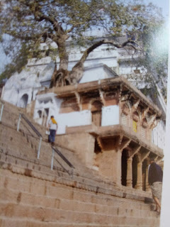
It is located at the summit of a conical hillock and hence the Sion Fort was provided with a small watchtower and one breastwork with 9 to 10 guns, 60 soldiers and 1 captain. Old Gazette records say at the borders of Sion, there was a large gate with a police station. This gate was closed once the cannon was fired at eight pm in the night and the gate was opened when the cannon was heard in the morning. At the mid level, a large fresh water tank was provided which acted as a catchment area of water from the hill top thereby supplying water to the soldiers stationed at the fort. This tank is now dry and overrun with vegetation and can be accessed by means of a flight of steps. There are several small chambers to provide respite from the harsh climate with pitched roofs with country tiles and barge details, similar to the ones which are often found in the Goan-Portuguese house below the main tower.
The fort commanded the passage from Bombay to the neighbouring island of Salsette and was of importance while the Marathas possessed the island, but it now only serves to beautify the scene. An alternative panoramic view from the vantage of Sion Fort, the view opens out to the island of Mahim. In this scene, the walls of the fort dominate the foreground, with the curving line of ramparts and imposing cannons mounted in the battlement wall. The rising staircase and buildings behind the gun carriage are surmounted by a flagstaff asserting British sovereignty over the island. Now, you get a good view of the refineries and salt pans on the east and an aerial view of the Eastern Express Highway.
 |
| The rock-like bastion at Rewa Fort |
The Sion Fort has two ramparts: the Rewa Fort and the Sion Tank. Traditionally, the Rewa Fort has been considered as part of the Salsette islands. Salsette originally consisted of dozens of smaller islands--its local name in Marathi, "Shashti" means "66 villages" which were separated by swampland. The places where the sea entered are between Rewa Fort and Mahim, Worli and Mahim Woods and between Breach Candy and Love Grove. At its Northern Extremity, the Bombay island is joined to that of Salsette by the Sion Causeway and the railway line parallel to it and by Lady Jamshedji's causeway to Bandra. A causeway from Mahim Fort at the Northwest extremity is continued eastwards past Rewa via Sion. The fusion of Salsette into Bombay was brought about through massive land reclamation projects which began in the 18th century and by the early 1900s, they had become one single island, divided from the mainland on the North by the Vasai creek and on the East by the Thane creek. Presently, the Rewa Fort has been ravaged due to the forces of nature leaving behind just a large rock-like bastion. The land that houses the Rewa Fort has been taken over by the Sion Ayurvedic College which now has a garden where medicinal plants and herbs grow as these are prescribed in the syllabus taught by the college. Hence, access to the Rewa Fort has been blocked completely in order to preserve the sanctity of the garden and the plants.
The Sion Tank is also a partial part of the Sion Fort. The tank is surrounded by a Bhavani Shankar temple and a tiny orange coloured idol of Lord Brahma. Most Shiva temples in India have a water body either in the form of a tank, river, pond or lake. According to mythology, it is believed that having a water body in the premises of the temple helps cool down Lord Shiva who is otherwise known for His destructive anger when in the form of Rudra. Before the Eastern Express Highway cut through this sacred land, this was one continuous spiritual place which had seven ponds around it of which only one survives today.
The Sion Fort is located at a walking distance from Sion station and you need to walk eastwards towards the Sion Flyover to reach the fort. The way up to the fort is like walking in a park and has an easy level climb up. The fort is in a dilapidated condition with broken steps, scattered walls and ruins, overrun by trees and excessive ground cover and is marked with lots of graffiti. Despite this, it makes for an ideal location especially for photographers looking for a view of the Eastern Express Highway.

Comments